
PQOG Guerrilla Intel Reports on Lipa, Batangas with Sketch Maps, December 44
[TRANSCRIPTION]
The President Quezon’s Own Guerrillas or PQOG was one of the guerrilla organizations operating in southern Luzon, and it had a sizable presence in the Province of Batangas. Included among the files1 of the PQOG’s composite 2nd Regiment is a summary of intelligence reports on the Japanese Army’s military activities, movements and positions in the then-town of Lipa, Batangas, with mentions of the nearby towns of Mataasnakahoy and Rosario. The entire summary is transcribed below.

Also included in this page are guerrilla sketches of what presumably were Japanese positions marked in red in the poblacion of Lipa as well as the Japanese-operated Lipa Airfield near the town of Mataasnakahoy. A legend to interpret the maps is provided at the bottom of this page.
Generally, sketch maps created by guerrilla outfits operating in Batangas aimed at pointing out to American military planners the positions of the Japanese Imperial Army insofar as these were concerned: troop quarters/positions; gasoline and supply dumps; military headquarters and buildings; artillery and anti-aircraft guns; general defenses like barbed wire enclosures and foxhole concentrations; and airfields and other hubs or locations of military transport.
ARF-PQOG
OFFICE OF THE G-2
In the Field
SUMMARY OF INTELLIGENCE REPORTS AS OF
DECEMBER 1, 1944
Lipa, Batangas
(2) 20 Jap planes destroyed.
(3) Runway on western side of field.
(4) 3,000 soldiers and workers.
(5) Fires on eastern side.
b. Ammunition depots.
b. Corner of Gen. Malvar & Gat Polintan Streets due southwest.
b. Cemetery in Mataas na Kahoy.
b. Alupay Barrio School.
c. Seminary on the same road.
d. Corner of National Road & Gen. Malvar Street.
2. Barrio Antipolo, 2 kms from the town.
2. Corner of 10 de Julio & Gregorio Aguilar Streets.
3. Corner of road to Rosario and A. Mabini Streets, 2nd house.
2. Soldiers go around the nearby barrios confiscating livestock, etc. without paying.
2. Foxholes & dugouts on the western slope of Anilao Hill.
3. Jap soldiers mixing with the civilian population.
4. Dummy airplanes in the barrio of Bagumbayan.
5. Real airplanes in the coconut groves.
Guerrilla Sketch Maps
Sketch Map of Poblacion Lipa
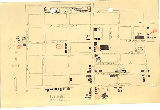 |
| Image source: Composite 2nd Regiment, I Corps, PQOG. |
Sketch Map of Lipa Airfield and Vicinity
 |
| Image credit: Composite 2nd Regiment, I Corps, PQOG. |
Guerrilla Sketch Map Legend
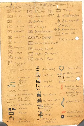 |
| PQOG Guerrilla Map Legend. |