
Lian, Batangas: Historic and Folkloric Notes about some of its Barrios
We take a look at the small western Batangas town of Lian to continue with our series of barrio history and folklore. The information contained in this article has been taken from documents required of all Department of Education districts in 1951 by the administration of President Elpidio Quirino to reconstruct local histories contained in documents destroyed during World War II. The documents, written by teachers, are archived at the National Library of the Philippines Digital Collections.
Not all barrios of Lian are included. Some of the town’s present day barrios might have been still part of other barrios when the documents were submitted. It may also be possible that there were barrios for whom no research was conducted; or if there was, the documents could have been destroyed or eroded by time before the NLP had undertaken its digitization project.
 |
| Image credit: Google Earth Street View. |
Binubusan
The old name of this barrio was Bayanan. Its present name was supposed to have been derived from the word “pinagbubusan.” The author of the source document stated that this was dialect, presumably in Lian, but did not categorically define it. Among its sitios were Balibago, Matabungkay, Luyahan, Turobayan, Litlit, Aguha, Matuod, Mainit, Kuwako, Elenahan, Matala, Pinagbarilanan and Karwahe. Binubusan’s earliest settlers were the Ruiz, Casihan, Macalalad, Hernandez and Austria families.
When the Philippine Revolution broke out in 1896, the people of Binubusan chose one Felipe Austria to lead them against the Spaniards in the barrio. The following year, Spanish forces arrived. The inhabitants of the barrio tried to hold them off using bolos and just 5 rifles. They were eventually overrun. When the US Army came to Binubusan in 1898, the leader of the local group of freedom fighters was quickly captured and his troops surrendered without loss of blood.
In 1943, Japanese troops came to Binubusan and occupied most of the houses in the barrio. The locals had earlier fled to the mountains. Upon learning that the Americans had landed in Nasugbu in Januarh of 1945, the Japanese withdrew from the barrio, presumably to consolidate their defenses elsewhere.
Source: History and Cultural Life of the Barrio of Binubusan
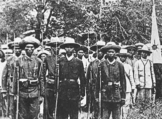 |
| Inhabitants of Binubusan joined the uprising against Spanish rule. Image credit: by Original uploader was Saluyot at ilo.wikipedia - Transferred from ilo.wikipedia; transferred to Commons by User:DieBuche using CommonsHelper., Public Domain, https://commons.wikimedia.org/w/index.php?curid=10282344. |
Kapito
This barrio was officially established in 1912, used to be heavily forested and had very few occupants. As more immigrants came, they started clearing forests. From a distance, the hills after the forests were cleared looked like they were divided into seven parts. Thus, the barrio’s name was presumably shorted from “ika-pito” or seventh, or so folklore went. Among the barrio’s pioneers were Luis Sanchez, Tranquilino Sanchez, Torobio Mendoza, Silvestre Guevara and Juan Hernandez.
From 1900 to 1919, the barrio saw little development. It did not have a school, chapel or even stores. A barrio lieutenant was not appointed until 1912. In World War II, Japanese soldiers made camp in Kapito and Banderahan, one of its sitios. They confiscated rice, poultry and livestock. Inhabitants of the barrio who refused to give these up were promptly killed.
Source: History and Cultural Life of the Barrio of Kapito
Malaruhatan
According to folklore, the barrio was originally a wilderness where the most common tree that grew was one called the “malaruhat1.” The tree is common enough in the Philippines and is alternatively called “molave” or “mulawin.” The barrio was officially established in 1927 and its original settlers were the members of the Gonzales family. Other settlers would follow and they would grow sugarcane, rice, corn, fruits and vegetables to sustain themselves.
The barrio had several sitios. These were Pajo, named after the miniature mango; Pader, so named probably because of rock cliffs that looked like a wall; Bagong Pook, so named because it was among the newest of the sitios established; Mahabang Parang, so named after its wide plains; and Hermosa, Spanish for beautiful, so named because of its scenic beauty.
Source: History and Cultural Life of the Barrio of Malarahutan
 |
| Malarahutan was another name for the molave tree (above) Image credit: Philippine Medicinal Plants. |
Prenza
This barrio’s old name was Balete, after a tree of the same name that once grew in the place. The name Prenza was supposed to have been given in reference to an irrigation dam2 that the Spaniards constructed to the southeast of the barrio. Among the barrios sitios were Lumaniag, Balete, Cruz, Humayingan and Ladron. It was officially established in 1902, having earlier been settled by no more than six families.
The source document contained very little information of note other than the opening in 1928 of a road that connected Palico, Lian and Calatagan. This allowed people of the barrio the opportunity to sell their produce in Nasugbu or Balayan. Many inhabitants of the barrio also left their homes on the banks of the river to build new homes along the road.
Source: History and Cultural Life of the Barrio of Prenza
Puting Kahoy
Puting Kahoy was supposed to have had several changes of names. It was earlier known, among others, as Aguha and Puting Mulawin. According to folklore, its official name was given after Spaniards looking for a tree which could be used to construct a public building pointed at a tree with white leaves, trunk and branches, and a local whom they asked for the name of the area thought they were asking for the name of the tree and replied, “Puting kahoy.”
The barrio’s sitios were Bigaa, Calamias, Aguha, Cumba, Sulsugin and Pinagkurusan. Little was known about its earliest settlers. The belief was that several huts were built where farmers could rest while they worked the fields or cleared the lands, but at the end of the day they returned to their homes in Balayan. Eventually, some of them would settle the barrio permanently.
Source: History of Puting Kahoy
San Diego
The origins of this barrio’s name could not be established, although the source document stated that since the olden days, the inhabitants of the place had always pronounced San Diego more as San “Digo.” Its sitios were Ligas, Baldeo, Caloongan, Tan-ag, Altura, Tulay-na-lupa, Palasanan, Bungahan, Kay Tambing and Kay Sapayo. The barrio was officially established in 1918.
2 The Spanish for dam is “presa.”