
US Army Surprises Japanese at Palico, Nasugbu in 1945, Bluff Its Way up to Tagaytay
[In this page: Nasugbu Landing, Palico Nasugbu, Palico Bridge, Tagaytay Ridge, Japanese soldiers WW2, US 8th Army]
On 31 January 1945, forces of the United States 8th Army landed on the beaches of Nasugbu. The purpose of the landing was twofold. Primarily, these troops were meant to block the retreat of Japanese troops forced south by the advance of the United States 6th Army from the north. If viable, the forces could also drive north in support of the 6th Army1.
By 8:15 that day, after an hour of shelling the beaches, landing crafts started ferrying troops to the shores of Nasugbu. By 9:45, the entire town, along with its landing strip, was completely in American hands. US Army troops had marched into the town to tumultuous greetings from locals. As much as these soldiers would have liked to have soaked in the warm welcome, they had to move on to take advantage of the Japanese troops’ withdrawal, caught by surprise as they were by the landing.
For more details about the Nasugbu landing itself, READ: “Details of the Historic Nasugbu Landing from the Viewpoint of the 11th Airborne Division.”]
 |
| A photo of the Palico Bridge in Nasugbu soon after the landing of troops at the beaches in 1945. Image source: "The Angels: History of the 11th Airborne Division 1943-1946." |
For those not familiar with Nasugbu, the Palico area is on the outer fringes of the town’s territory and was likely so named because of a road that wound around hilly terrain.
At the Palico Bridge, a gateway to the mountains where the Japanese had retreated to dig themselves in, the 188th had a stroke of luck and, in a figurative sense, caught the Japanese with their pants down. Major Edward M. Flanagan Jr., in his book, described what happened,
“The advance had been so swift that the Japs who had the steel-trussed span mined were caught on the far side of it. They attempted to get to their detonator but our fire from the west bank of the Palico killed six and forced the rest to withdraw toward Tagaytay Ridge. Capture of the bridge allowed us to keep moving ahead. Its destruction would have seriously delayed us since our engineers did not have the equipment to replace it. Bypassing would have been difficult because the Palico River flows in a deep, steep-sided canyon, as do most of the Luzon Rivers.”
That the Palico Bridge remained intact would be crucial to how subsequent events would unfold. Speed was of the highest essence to the Americans. The landing of troops at Nasugbu, Flanagan explained, was something of a “strong reconnaissance.” What this meant was that one regiment would be sent ashore to test resistance from the Japanese, with the option to withdraw if defenses were strong. By noon, when it was evident that the Japanese had been caught by surprise and had withdrawn up to the mountains, American commanders decided to fully exploit the situation.
The Americans had to keep pushing forward because the Japanese were in retreat. To pause would give the latter the chance to reorganize. Also, the American forces were relatively small in contrast to the reported number of Japanese troops. To keep moving in pursuit of the latter was something of a bluff that the Americans were playing on their enemies. Flanagan elaborated:
“On Luzon south of Manila, G-23 reports claimed the presence of at least 50,000 Japs. We had about 7,800 men including port details, service units and men in hospital. We were pulling the supreme bluff. By roaring down the road, raising a lot of dust, moving in fast and shooting quickly we left the Japs with the impression that an army complete with an armored division was making an invasion in force against them on Southern Luzon. Instead, the invading task force was a light, airborne division, under-strength and under-manned. Replacements for our Leyte losses had not been received.”
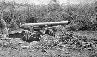 |
| Abandoned Japanese artillery at Barrio Aga, Nasugbu. Image source: The Angels, a History of the 11th Airborne Division. |
READ: How Batangas was Liberated by Allied Forces from the Japanese in 1945.
2 The 188th Glider Infantry Regiment was a World War II group of the United States Army assigned to the 11th Airborne Division. Wikipedia.
3 G-2 is an intelligence unit of the United States Army. Wikipedia.
4 A defile is a narrow passage between hills, rocks and cliffs. Merrian-Webster.