The American colonial era in the Philippines began with the cessation by Spain of the latter to the United States in 1898 and ended with the granting of full independence to the Philippines by the United States on 4 July 1946. The early years of American colonial rule were marked with strife as the Filipino revolutionaries refused to accept being ruled by another foreign power so soon after disposing of the former.
That said, when political conditions began to stabilize and the normalcy resumed, the Americans went about the business of improving infrastructures like roads, bridges and public buildings which the Spaniards had heretofore neglected and also made public school education available to the masses in the country.
This article documents some rare photographs of taken from that period in Philippine history.
 |
| Image credit: Harry S. Truman Library & Museum. |
The picture above wa at the Harry S. Truman Library & Museum’s Digital Collection. It was taken circa 1945 so this was about the time of the liberation of the country from the yoke of Japanese occupation. Here is how the image was captioned: “A street in an unidentified city in Batangas Province, Luzon, Philippines. Old cars can be seen parked along the sides of the street. All people are unidentified. Donor: John Paxton.”
The next four pictures are from the University of Wisconsin Digital Collections. The original pictures were dark and scanned at a low 72 dots per inch, so there was some loss in quality when I enlarged them. Given that photography was still an emerging technology in the late nineteenth century, there is only so much that graphic software can do to improve quality. These are still an improvement over the originals. These photographs have been optimized for faster downloads. The originals may be obtained fromt he University of Wisconsin web site.
 |
| Image credit: U.S. National Archives; University of Wisconsin Digital Collections. |
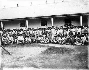
The picture above was taken in 1898 and captioned “General prisoners, Batangas.” The Battle of Manila between Commodore George Dewey’s troops and those of the Spanish colonial forces did not commence until August 1898; while the Fil-American War did not break out until February 1899. Chances are that the prisoners above were Filipino revolutionary fighters freed upon Spain’s surrender to the Americans. For all we know, of course, these were just common criminals. Either this or the date given was erroneous.
 |
| Image credit: U.S. National Archives; University of Wisconsin Digital Collections. |
The above photograph was taken in 1899 and captioned “Female prisoners, Batangas.” The presence of children in the image, however, makes me wonder if the picture was mislabeled. Note the attire which although typical of the late nineteenth century Spanish era was also so inappropriate given the heat and humidity. Then again, there is every possibility that this picture was, indeed, taken during the Fil-American War and, as with the previous picture, mislabeled in terms of date.
 |
| Image credit: U.S. National Archives; University of Wisconsin Digital Collections. |
Above, a picture taken between 1905 and 1915 in the small town of Calaca, Batangas. The picture was captioned “Women ginning, carding, spinning and weaving cotton, Calaca, Batangas, 1905-1915.” This may come as a bit of a surprise because the town in the present day is, perhaps, more known for its sugarcane production. But yes, cotton used to be planted not just in Calaca but elsewhere in the province; and the Philippines were, during the Spanish era, an exporter of cotton1.
 |
| Image credit: U.S. National Archives; University of Wisconsin Digital Collections. |
The picture above was taken in 1927 and captioned “Harvesting coffee, Batangas.” Although the coffee industry in Batangas had declined from its lofty perch back in the nineteenth century, chances still are that the photograph above was taken in the then-town of Lipa.
* * * * *
The next photographs were taken by the Minnesota-born botanist Robert Larimore Pendleton. He was in the Philippines from 1923-19352. The pictures are part of albums available at the University of Wisconsin Milwaukee web site. These pictures are of higher quality than the preceding ones.
 |
| Image credit: University of Wisconsin Milwaukee. |
The above picture was taken by Pendleton in 1934 at what used to be the barrio of San Nicolas, at the time part of the town of Taal. It was captioned “San Nicolas Road, Taal--Lake, Batangas [province]. Jan. 6, '34. San Nicolas road.”
 |
| Image credit: University of Wisconsin Milwaukee. |
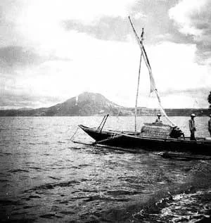
The picture above was taken by Pendleton in 1933. It is captioned “Cuenca, Pansipit River, & Taal Lake. Nov. '33, Batangas Province. Taal Lake. Sailing banca. Mt. Macolot [Mount Macolod] beyond. to N.E.” I am certain that this was taken from the shores of San Nicolas because I have pictures of my own from the same vantage point, albeit taken from the present day wharf and promenade.
 |
| Image credit: University of Wisconsin Milwaukee. |
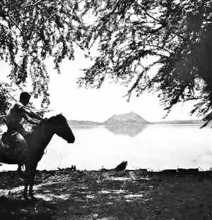
The above picture was taken in 1934 and Pendleton captioned it this way: “Talisay--Tagaytay Trail, Batangas. Aug. 23, '34. Taal Id. [Volcano Island] (NW corner). Glimpse thru kamachile (pithecolobium dulce) trees. 11 1/50 G. Panatomic 6 x 6.” Visible in the distance is the Binintiang Malaki crater of Taal Volcano, sometimes referred to in the present day as the fake volcano.
 |
| Image credit: University of Wisconsin Milwaukee. |
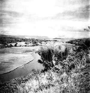
Pendleton took the picture above in 1933, and in his photographer’s notes gave it the caption “Cuenca, Pansipit River, & Taal Lake. Nov. '33, Batangas Province. Looking up Pansipit River. Taal volcano [Volcano Island] in distance below Tagaytay Ridge.” It is hard to discern the contours of the Pansipit River, though, lost as it appears among the grasslands and ricefields.
 |
| Image credit: University of Wisconsin Milwaukee. |
The picture above was taken in 1933, and in Pendleton’s notes, he gave it the caption “Macolot Mt. [Mount Macolod] and Pansipit Road, Batangas. Nov. 30 '33. Wayfarers on Taal Bulayan road. Eastman Panchromatic Rolleiflex.” Unless there is a barrio in Batangas that I have not heard of named “Bulayan,” then we can all safely assume this was a typographical error and what was intended was “Taal-Balayan” road.
 |
| Image credit: University of Wisconsin Milwaukee. |
Above, a picture taken by Pendleton in the town of Tanauan in 1933. In his notes, Pendleton gave the picture the caption “Solis Building; Tanauan Market; Mt. Macolot [Mount Macolod], Batangas. Caretelas at Tanauan. Eastman SS Panchromatic.”
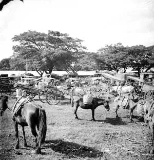 |
| Image credit: University of Wisconsin Milwaukee. |
Finally, the picture above was also taken in 1933 at the Tanauan Market by Pendleton. In his notes, the caption was: “Soils Building; Tanauan Market; Mt. Macolot [Mount Macolod], Batangas. Pack horses at Tauauan Market on a Thursday. Eastman SS Panchromatic.”
Notes and references:
1 “Cotton in the Philippines,” by Maribel Ongpin, published 2014, online at the Manila Bulletin.
2 “Pendleton, Robert Larimore,” Islapedia.
