The photographs contained in this collection are taken from a dossier dated November 1944 entitled “Terrain Study No. 95 Batangas-Lucena.” The declassified document was originally from the Allied Geographical Section called the Southwest Pacific Area (SWPA), which was responsible for the liberation of the Philippines from Japanese occupation in World War II. This so-called SWPA was under the command of General Douglas MacArthur.
The document, which was basically a collection of photographs and maps, was likely used as intelligence prior to the liberation of southern Luzon from Japanese control. The photographs were all taken before the outbreak of World War II in the Philippines in December 1941. All labels are as written in the original document.
 |
| Actual cover of the Allied intelligence terrain study. |
 |
| Beach at Batangas, looking east. 1938. |
 |
| Batangas Pier; looking north. 1936. |
 |
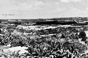
| Town of Lemery; showing beach and Route 17. Looking NW. Aerial oblique. 1935. |
 |
| Towns of Lemery and Taal, showing terrain; looking east. Aerial oblique 1935. |
 |
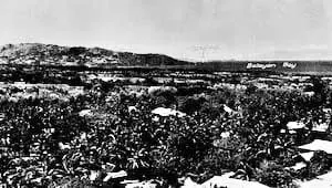
| Beach fronting Balayan town, showing swampy terrain in background; looking north. Aerial oblique. Pre-war. |
 |
| Nasugbu, showing airfield and beach, looking WSW. Aerial oblique 1937. |
 |
| Nasugbu and coastline northward, showing Mariveles Mountains in background; looking WNW. Aerial oblique. Pre-war. |
 |
| Coastal flat south of Taal; looking south. Pre-war. |
 |
| Coastal plain west of Lemery; looking WNW. Pre-war. |
 |
| Pansipit River at outlet from Taal; showing native fish trap. Pre-war. |
 |
| Batangas Airfield, showing proposed extensions. Vertical. 1937. |
 |
| Calatagan Airfield, looking south. Aerial oblique. 1937. |
 |
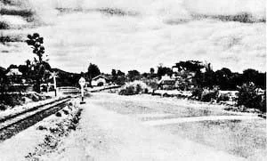
| Route 17, between Batangas and Bauan. 1938. |
 |
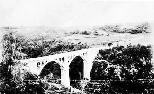
| Manghinao River bridge; Route 17 at Km. 155.0. Prior to 1929. |
More correctly, the bridge above was the Manghinao Bridge, a 15-meter concrete arch at Kilometer 122.2 along the Bauan-Taal Road1.
 |
| Railroad crossing at Mahabangparang on Route 420, showing elevated ridges on road to reduce speed. 1935. |
I am unable to find information on a Route 420, but there is a barangay in Batangas City called Mahabang Parang. Chances are the photograph above is part of the Batangas City-Calamba railroad line that existed before WWII.
 |
| Rancho River Bridge, Route 17, at Km 2.2 from Banaybanay. 1929. |
This Rancho River is in the present day a creek at the western outskirts of what is now the City of Lipa near its border with the adjoining town of Cuenca.
 |
| Sabang Bridge. Route 19. Pre-war. |
Just to be clear to those from Lipa City where there is also a bridge loosely referred to as the Sabang bridge, the one above was of the Batangas-Ibaan Road2.
 |
| Palico River bridge, Route 410, at Km. 0.5. 1927. |
The Palico Bridge was a 160-foot steel pin connected truss bridge along the Batangas-Nasugbu Road. The bridge was completed and made available to vehicular traffic on March 20, 19261.
 |
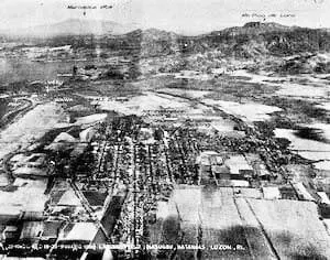
| Batangas Town and airfield; looking south. 1936. |
 |
| Batangas Town. Vertical. 1940. |
 |
| Malvar railroad junction; looking WNW. Aerial oblique 1933. |
Train service used to exist from Batangas City to Calamba and onto Manila. One of the stops was at Luta, presently part of the municipality of Malvar.
Notes and references:
1 “Quarterly Bulletin Compilation, Bureau of Public Works.”
2 “Sabang bridge on the Batangas-Ibaan Road,” online at the United States Library of Congress.
3 All photographs above taken from “Terrain Study No. 95, Batangas-Lucena,” Allied Geographical Section, Southwest Pacific Area.
