
Two Tagaytay–Batangas Shortcut Roads Built by US Army Engineers in 1945
[In this article: US Army Corps of Engineers, World War II, Tagaytay to Lemery Road, Tagaytay to Talisay Road]
As the liberation of the Province of Batangas by the United States Army from Japanese occupation went into full swing early in 1945, the United States Army employed a two–pronged pincer attack from the town of Nasugbu where its troops had landed on the last day of January. One arm of the pincer swung south through Tuy, Balayan and Lemery before heading south to the Calumpang Peninsula and Batangas Bay. The other headed west through Tagaytay then south to Tanauan through Talisay.
As the American soldiers advanced deeper into the province, with the advance came the logistical problem of keeping communication and supply lines open with the troops in the front. From the landing of forces on the beaches of Nasugbu, by February the headquarters of the 11th Airborne Division, the spearhead group of the campaign in Batangas, was transferred to Tagaytay Ridge1.
The southern Arm of the pincer was assigned to the 158th Regimental Combat Team (RCT), which met little resistance after leaving Nasugbu until it reached the outskirts at Lemery. To get to Lemery from Tagaytay meant making the roundabout using Route 17 down to Batulao and Palico through Tuy, Balayan and Calaca. Given the demands of warfare, a shorter route was necessary.
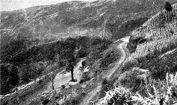 |
| The Talisay to Tagaytay road in 1945. Image source: The Angels: A History of the 11th Airborne Division 1943-1946. |
“In order to cut off the long round-about trip from Division Headquarters on Tagaytay Ridge, back to Palico, through Balayan to Lemery, the engineers built a road on the edge of the cliff which is the western shore of Lake Taal. From the western end of the Tagaytay Ridge Road, down the crest of Shorty Ridge, they cut a dusty, twisting, narrow road which debouched2 from the foothills of Mt. Batulao just west of Lemery. This one came to be called the Shorty Ridge road, and it shortened the trip to the 158th by one-fourth.”
 |
| The present-day Diokno Highway leading to Batulao. Image source: Google Earth Street View. |
“The third road which the engineers constructed was the most amazing. It came to be called the Stilwell Road, after pictures we had all seen of the Ledo Road in Burma. The steep, sheer cliff on the north side of Lake Taal is vertical, except for razor like noses that corrugate its surface. The top of the ridge is 2,400 feet above sea level, and except for 200 feet of that distance, which is used to get from Balayan Bay to the southern lake shore, the entire 2,400 foot elevation is taken up in the straight distance between the ridge and the north shore of Lake Taal directly below it.”
 |
| The Ligaya (or Lagaya) road in Talisay which leads up to Tagaytay. Image source: Google Earth Street View. |
“Halfway from Tagaytay Ridge to Manila there was a small town named Silang. Here the engineers found a narrow dirt road which led from Silang to the western shore of Laguna de Bay, emerging just south of Muntinlupa. They widened this trail, bridging and bypassing ravines and streams, and opened it as a temporary supply road. It cut the original route by about seventy miles. It was still too long, however, and the engineers next moved farther south. Where the highway turns to the north to leave Tagaytay Ridge and head for Manila, there was another narrow road leading due east, over the top of Mt. Sungay3, and down, so the map said, to the town of Calamba in the southwestern corner of Laguna de Bay.”
 |
| The treacherous Tagaytay to Canlubang road in 1945. Image source: The Angels: A History of the 11th Airborne Division 1943-1946. |
2 In this context, debouch means “to emerge from a relatively narrow valley upon an open plain.” Dictionary.com.
3 Mount Sungay is an inactive volcano to the east of the Tagaytay mountain range. It is within the boundaries of the Province of Cavite. “Mount Sungay,” Wikipedia.