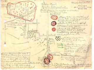
WWII Intelligence Map Showing Japanese Positions West, South of Lipa, Batangas
Below is a digitized copy of an intelligence sketch created by a guerrilla unit on Japanese positions and installations at the western and southern outskirts of the then-town of Lipa, Batangas during the Japanese occupation. The sketch was among the files1 submitted by the Lipa Guerrilla Regiment (Paran’s Unit) to the United States Army in its application to be recognized as an element of the Philippine Army in the service of the Armed Forces of the United States during the liberation of the Philippines.
The original map was sent by the guerrilla unit to the Allied Intelligence Bureau for use in military planning. It was titled “Sketch Showing the Western and Southern Outskirts of the Town of Lipa.”
Inside the map was handwritten this legend to help in interpretation:
[Encircled with red crayon with red spots inside] “Region to be air-scouted and enemy to be machine-gunned or bombed accordingly.”
[Black and red crayon circles with red spots inside.] “Anilao Hill to be crushed whenever the enemy appears in any section of the place.”
[Circle with thick red crayon border and red spots inside.] “Antipolo school building and premises used from time to time as storing place for ammunition, explosives, etc.”
The black red spots to the lower right of the map represent “Section where some foxholes and dugouts are found. Below the spots, the three green arrows represent “A wide area where tanks, mechanized units, land forces, parachutists, etc. may get in without much fear of any resistance.”
The text near the marker for Anilao Hill reads: “Tunnels, trenches, dugouts, foxholes bordering the eastern, southern, western, and northern slopes of Anilao or Lipa Hill.”
The text to the lower left hand corner reads: “About 100 meters south of Antipolo schoolhouse lies a narrow part of the provincial road where mines or dynamites were planted. From this spot, tunnels or deep trenches were dug long [curious usage of this word] eastward toward the creek, and another westward toward the foot of Anilao Hill.”
Click here to download a high resolution version of the map in PNG format.


