Intel Reports on the Jap Army in Lobo, Malvar, Rosario, San Jose and San Juan, Batangas, Dec 44 - Batangas History, Culture and Folklore Intel Reports on the Jap Army in Lobo, Malvar, Rosario, San Jose and San Juan, Batangas, Dec 44 - Batangas History, Culture and Folklore

Intel Reports on the Jap Army in Lobo, Malvar, Rosario, San Jose and San Juan, Batangas, Dec 44

The President Quezon’s Own Guerrillas or PQOG was one of the guerrilla organizations operating in southern Luzon, and it had a sizable presence in the Province of Batangas. Included among the files1 of the PQOG’s composite 2nd Regiment is a summary of intelligence reports on the Japanese Army’s military activities, movements and positions in the then-towns of Lobo, Malvar, Rosario, San Jose and San Juan, Batangas. The contents of the summary are transcribed below.

Also included in this page are guerrilla sketches of what presumably were Japanese positions marked in red in these same towns. A legend to help interpret the maps is provided at the bottom of this page.

Generally, sketch maps created by guerrilla outfits operating in Batangas aimed at pointing out to American military planners the positions of the Japanese Imperial Army insofar as these were concerned: troop quarters/positions; gasoline and supply dumps; military headquarters and buildings; artillery and anti-aircraft guns; general defenses like barbed wire enclosures and foxhole concentrations; and airfields and other hubs or locations of military transport.

US Army soldiers in WWII
US Army soldiers in WWII. Image has no relation to content. Credit:  US National Archives.

Transcriptions of Intelligence Reports

ARF-PQOG
OFFICE OF THE G-2
In the Field

SUMMARY OF INTELLIGENCE REPORTS AS OF
DECEMBER 1, 1944

Lobo, Batangas

A. Troops.
1. Tabangao.
a. 1,000 men along the coast for beach defense.
2. Poblacion.
a. 12 men in permanent garrison.
3. Ligwayin & Manila Mountain.
a. 1,000 men in promontory in the vicinity of Dagatan Lake, due east.
4. Masagitsit Barrio School.
a. 30 men.
5. Suloc Barrio School.
6. Malabrigo Barrio School.
a. 150 men.
B. Installations.
1. Radio station with 50 cal. (AA) MG.
a. Masagitsit Barrio School.
C. Miscellaneous
1. Lobo Harbor & Malabrigo Point are stopping places for vessels.
Guerrilla sketch map of the Japanese Army in Lobo.
PQOG sketch map of the Japanese Army in Lobo.
Malvar, Batangas
A. Raids.
1. Oct. 6, 1944.
a. Barracks with 13 Japs & equipment destroyed.
b. 2 train wagons with gasoline, 1 wagon with 6 unassembled airplanes destroyed with 3 Japs killed.
B. Troops.
1. Barracks along western side of RR track.
2. Barracks along the road to San Pedro 1 km from the RR track, due west.
PQOG sketch map of the Japanese Army in Malvar.
Rosario, Batangas
A. Troops.
1. Rosario Elementary School.
B. Ammunition.
1. Rosario Elementary School.

San Jose, Batangas

A. Troops.
1. Commanding General.
a. House, 100 meters from the bridge due west, north side of National Road.
2. Soldiers.
a. Heavy concentration in Public School building, south side of the National Road, 800 yards from the church.
B. Ammunition – Bombs & Shell.
1. R.C. Church, ground floor, west wing.
C. Artillery & AA Guns.
1. Base of Soro-Soro Hills.
a. Field artillery pieces.
2. R.C. Church tower.
a. AA machine gun.
D. Food and other supplies.
1. Public School building.
PQOG sketch map of San Jose.
San Juan, Batangas
A. Raids.
1. Nov. 19, 1944 – 1:20 p.m.
a. Looc-Loco Pt.
(1) 2 cargo vessels sank.
b. Malabrigo Pt.
(1) 4 cargo vessels set on fire.
B. Troops.
1. Poblacion.
a. 100 men, 21 Military Police.
2. Palahanan Sico Barrio School.
a. 100 men.
3. Natu.
a. 150 men.
4. Catmon.
1. 100 men.
C. Emplacements and Constructions.
1. Anti-aircraft gun.
a. Poblacion – no definite position.
2. Field Artillery.
a. 3 75-mm guns at Gulugud Baboy Mts.
3. Machine Guns.
a. Lipahan, along the riverside, due north.
b. Tipas
4. Dugouts and Foxholes.
a. Lipahan, along the riverside due north.
b. Tipas.
c. Along the river south of the poblacion.
d. Along the Lawayo River.
e. Natu.
5. Bridges.
a. Lawaya River, west of the public market.
D. Installations.
1. Radio transmitter & receiver.
a. Former Constabulary garrison.
2. Telephone.
a. Rosario to San Juan.
E. Ammunition & Supplies.
1. New school building.
a. 4 truckloads of ammunition.
2. Shop building.
a. Half-filled.
3. 6 truckloads of ammunition passed on the way to Candelaria.
F. Miscellaneous.
1. Col. Hugisigi2, Jap C.O. for the province, arrived 12 Nov. 44, emphasized full cooperation of the townspeople.
2. Landowners called to meeting, 13 Nov. 44, by Jap officers who asked for a quota of 700 cavanes of rice for the soldiers.
3. Labor conscription in barrio Quipot to work on fortifications at Natu.
4. Frequent patrols in the barrios along the seacoast.
5. Jap-supervised home guards being organized.
6. Animals (horses & cattle) and men recruited for labor to transport supplies to Natu on 24 Nov. 44.
7. 2 dummy tanks in front of the new school building.
8. Poblacion patrolled nightly.
9. Crews of transient vessels anchored along the coast go ashore during daytime and go aboard at nightfall.
PQOG sketch map of Poblacion San Juan.
PQOG sketch map of Mt. Natu, San Juan.

Guerrilla Sketch Map Legend

Guerrilla Sketch Map Legend
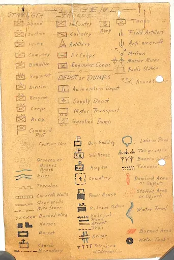
PQOG Guerrilla Map Legend.

Notes and references:
1 From the files of the Composite 2nd Regiment, I Corps, President Quezon’s Own Guerrillas, online at the United States National Archives. 2 Masatoshi Fujishige.
Next Post Previous Post