
Map of Operations During and After Nasugbu Landing, 3rd Bn Nasugbu Fil-Americans
Below is a sketch map of the sector of operations of the 3rd Battalion, 2nd Regiment of the Nasugbu unit of the Fil-American Troops during and immediately after the landing on the beaches of Nasugbu by the United States Eighth Army. This fairly detailed map has been digitally extracted from the files1 on the guerrilla outfit originally taken from the web site of the PVAO.
The map shows Japanese zones of operation as well as positions at barrio Wawa; the garrison at the sugar central at barrio Lumbangan; San Diego Point; at the Palico junction; at Pasong Cawayan and others.
To the lower left-hand side of the map are also enumerated the supposed accomplishments of the battalion such as the repair and construction of bridges, watch towers, an enemy stockade and other jobs that freed American soldiers to concentrate on combat duties.
Map of Operations, 3rd Bn, 2nd Regt, Nasugbu FAIT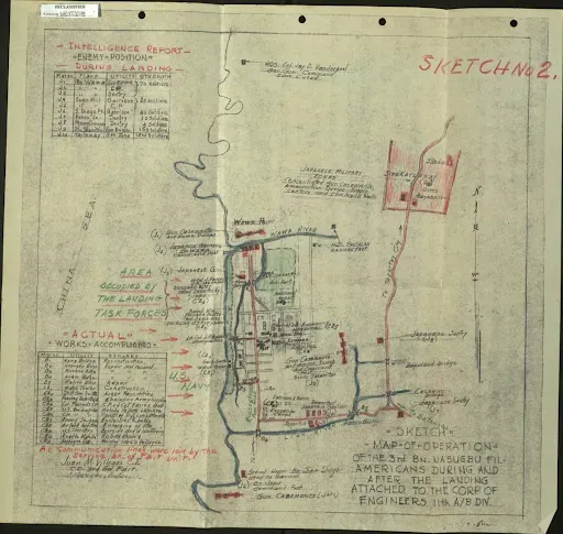 |
| Map of Operations of the 3rd Battalion, 2nd Regiment, Nasugbu FAIT. |
Click to download/view high resolution version of the map above.