
Antique Map Chronicles 18th Century Eruptions of Taal Volcano
At Google Arts & Culture1, there is a feature story on an antique map that chronicles the series of eruptions of Taal Volcano in the 18th century. The map is a digital copy of the original which is kept at the Archivo General de Nacion or the state archive of Mexico. The creator of the map is not known.
The map was originally found in a file of the Viceroyalty government of Nueva España or New Spain, Spanish territories in North and South America as well as in the east. Its capital was in what would become Mexico City2.
 |
| 18th century map of Taal Volcano Eruption. Image source: Google Arts & Culture, Archivo General de Nacion (Mexico). |
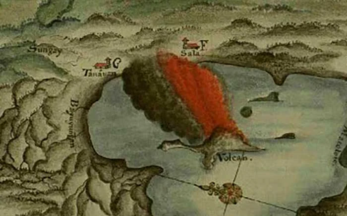
The map was supposed to have accompanied a written account of Taal Volcano’s activities in the first half of the 18th century, with recorded eruptions in 1707, 1716, 1729, 1731 and the most explosive one in 17493, or at least up to that point. As explosive as this last one was, it was to be followed by an even more cataclysmic one in 1754 when the volcano would erupt from May to December of that year.
From the information above, we can discern that the map was likely created before 1754. This was because during the protracted eruption of Taal Volcano that year, it spewed so much debris into the atmosphere that the entire channel erstwhile connecting the inlet in which the volcano was located to Balayan Bay was closed off, except for what would ultimately become the Pansipit River.
The map above shows the channel of water connecting the inlet to Balayan Bay still very much open. This channel was large enough to allow Spanish galleons arriving from Mexico to sail through. This was documented by the Augustinian friar Fr. Buencuchillo, who in writing about the 1749 eruption said that he mistook the first blasts for artillery fire which traditionally welcomed arriving galleons.
 |
| What became Taal Lake was once connected to Balayan Bay by a channel wide enough to allow Spanish galleons to sail through. |
 |
| Puerto de Taal or the port of Taal was, at this time, still the capital of Batangas Province. |
Meanwhile, two pueblos which would be rendered uninhabitable by the 1749 eruption of the volcano, Tanauan and Sala, are in the map still distinct population centers. Tanauan appears to be in the vicinity of what is now the municipality of Talisay, while Sala, of which the aforementioned Fr. Buencuchillo was parish priest, was farther north, probably in what is now the barrio of Ambulong or Bañadero.
So destructive was the 1749 eruption that inhabitants of Tanauan and Sala moved inland away from the volcano into what would eventually be the location of modern-day Tanauan. The Jesuit scientist Fr. Miguel Saderra Maso noted that “Sala was united with the latter town (Tanauan)4.”
 |
| The map shows Tanauan and Sala as separate pueblos. They would become one after the 1749 eruption of Taal Volcano. |
 |
| Lipa was probably still in what is now the barrio of Lumang Lipa in Mataasnakahoy. |
The pueblos of Bauan, Batangas, Rosario, Nasugbu and Liang, as Lian used to be called, are all indicated in the map. However, all these were in most likelihood, except for the inevitable ashfall, not as badly affected as the previously mentioned pueblos.
The map, in fact, gives a clue as to which locations were affected by the effects of the eruptions — green showing what must have been lush vegetation, and gray/flesh indicating how far volcanic debris reached. Except for the area due east of the volcano, which the map shows as green, practically the entire area surrounding the volcano was badly affected by the string of 18th century eruptions.
From all indications, this map must have been created in the aftermath of the 1749 eruption of Taal Volcano. Less than a decade from this, however, a more severe eruption would occur that would alter the topography of Batangas. The channel connecting the inlet to Balayan Bay would be closed off by volcanic debris. This debris, in time, would become new land which people would eventually settle. Moreover, the waters of the former inlet, which used to be marine or saltwater before the 1754 eruption, would be diluted by rainwater and water from springs, and be transformed into a freshwater lake as we know it in the present day.
2 “New Spain,” Wikipedia.
3 “The Eruption of Taal Volcano January 30, 1911,” by Rev. Miguel Saderra Maso, S.J., published 1911 in Manila.
4 Maso, ibid.