
Summarizing the 8th Army’s Report on the Nasugbu Landing of January 1945
The landing of American forces on the beaches of Nasugbu on the 31st of January 1945, known within military circles at the time as Operation Mike Six, counts as among the most significant events of World War II in the province of Batangas. The American forces were from the United States 8th Army, consisting primarily of the 11th Airborne Division; and its primary goal was to support the 6th Army, which had landed in Lingayen on the 9th of the same month, in its drive south to recapture the capital city of Manila from Japanese hands.
From the now-declassified official report1 filed by Lt. General Robert L. Eichelberger, Commanding General of the 8th Army, we are able to obtain snippets of information that allow better understanding of the operations that went on prior to, during, and after the landing.
Prelude to the Landing
In the report’s foreword, Eichelberger acknowledged that Operation Mike Six was conceived during a high-level meeting of army planners in November 1944 in the island of Leyte. The primary objective of a south Luzon landing was to “disrupt Japanese lines of communication, create a diversion to support the main landing at Lingayen and, if possible, even occupy Manila itself.”
The 11th Airborne Division was given the task of landing troops initially as a “reconnaissance in force” on the beaches of Nasugbu. This meant initially landing a limited number of forces to probe enemy defenses, and following this probe with a full-scale landing if it was seen to be viable2.
To distract the Japanese and make them think that a Luzon landing by the United States forces would be made south of the island, i.e. Bicol and Batangas Town3, diversionary “feints” or operations were undertaken on Mindoro and Marinduque so that the Japanese would be “caught off balance when the 6th Army thrust into the central plains of Luzon...” Before they could recover, the 8th Army would follow “through with high-speed amphibious and airborne thrusts from the southwest.”
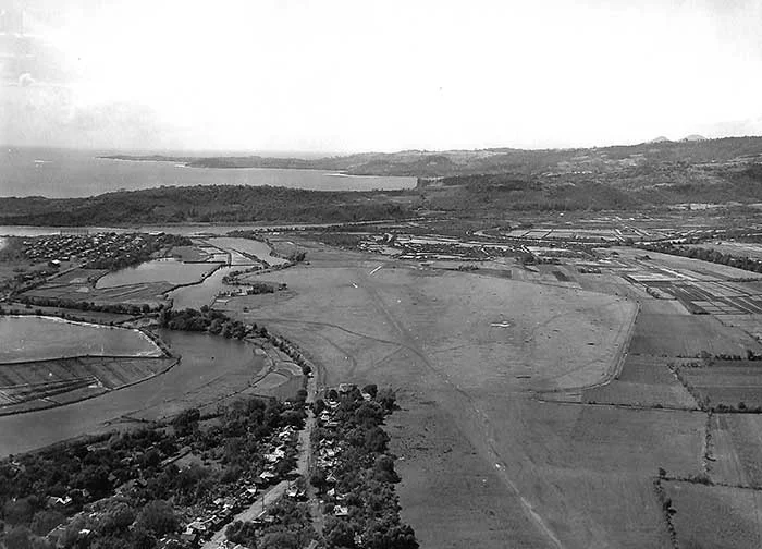
Factoring in Geography and Climate
The town of Nasugbu was chosen over other landing sites partly because of reconnaissance and guerrila reports stating that the landing beach would be good. Eichelberger’s report stated that it actually “proved to be poor,” saying that “anchorage space was extremely limited.”
Furthermore, the report said that the port and docks were “in poor condition” and did not offer a lot of “possibilities for large-scale handling of materials.” It was fortuitous, however, that there were many guerrilla outfits operating in or near the town; and many of these guerrillas would be employed by the United States Army for the unloading, transport and security of the supplies.
The report noted that the two intersecting runways of the pre-war landing field erstwhile owned and operated by Roxas y Cia were increased from 1920 feet and 1350 feet both to 4000 feet. However, because neither runway had a concrete surface, “its natural ground surface made it unserviceable in wet weather.”
The movement of troops and equipment was limited in times of heavy rain to existing roads; and this was an obstacle to the desired speed and lateral deployment the same. The movement of wheeled vehicles was largely dictated by the weather, something not helped by the presence of “numerous rice paddies and swamp areas bordering the coast...”
Execution of Invasion Plans
Despite the obvious challenges posed by geography and climate, not to mention tropical diseases such as malaria, dengue, typhoid, and dysentery, the 8th Army was able to execute plans as directed by the office of the Southwest Pacific Area under General Douglas MacArthur. Details of the invasion or landing were given by the report.
At 7:15 in the morning of 31 January 1945, naval guns and Allied airplanes began bombarding the beach of Nasugbu as well as San Diego Point. The initial salvo, said the report, “drew no return fire,” i.e. from the Japanese. By 8:30, the initial wave of troops — the 187th Glider Regimental Combat Team — landed on what was designated as “Red Beach.” At this point, there was some light machine gun and 75mm artillery fire coming from Nasugbu Point.
The insignificant Japanese fire coming from Nasugbu Point was quickly silenced by artillery fire and troops deployed to the area, so that by noontime, the invasion “had pressed inland to the sugar central previously selected as the division command post.”
Whatever resistance the little Japanese presence offered was in caves near the Nasugbu beaches and San Diego Point, and this was completely eliminated by late afternoon. Essentially, the Japanese defenders had bought the “feints” executed by the United States Army so that Nasugbu, the actual landing point, was lightly defended.
The report observed: “The surprise and speed of our landing and advance had left the enemy thoroughly disorganized, and he was unable to offer serious opposition to our progress.”
By half past three that same afternoon, American troops had seized the Palico Bridge “so quickly that the enemy was unable to destroy it” even though “demolitions (had been) placed throughout the bridge by the Japanese.”
The capture of the Palico Bridge intact by American forces would, of course, open the gates into Tagaytay. There, the Japanese had dug themselves in and offer greater resistance to American forces who were seeking to race north to the capital city of Manila.
2 “Reconnaissance,” Wikipedia.
3 Now the “City of Batangas.”