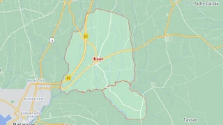
Map of Ibaan, Batangas
The town of Ibaan in the province of Batangas, named after the iba tree, a close relative of the calamias or bilimbi, is a 2nd income class municipality. Lost in history is the little known fact that the seat of the provincial government relocated temporarily to Ibaan shortly after the Japanese attacked the Philippines late in 1942; and this effectively made the town the provincial capital, albeit temporary, for a brief period of time.
Ibaan has 26 barangays and is part of Batangas’ 4th legislative district. It is known for its mosquito net (or “kulambo”) making industry as well as the production of the delicacy known as “tamales,” a local take on the Mexican tamale. Ibaan can be reached by road from Manila via the Southern Tagalog Arterial Road via its own exit or through the City of Lipa.
The town's land area is 6,899 hectares while its 2020 population was pegged at 58,507 inhabitants.
To see an interactive map of Ibaan, please click on the static image below. You will redirected to Google Maps using a new browser tab.