
Map of San Nicolas, Batangas
The town of San Nicolas along the shores of Taal Lake — although part of it is on the Main Taal Volcano Island Crater, no less — is the smallest geopolitical subdivision of Batangas, with a total land area of just 1,437 hectares. It is a 5th income class town with a population of 23,908 as per the 2020 Philippine Census. The town is part of the Province of Batangas’ 3rd legislative district.
This small town, however, has more than its lion’s share of history since this was the site of old Taal, until the latter was forced closer to Balayan Bay by the 1754 cataclysmic eruption of Taal Volcano. When Taal was still in San Nicolas, it was also the provincial capital.
This town can be reached from Manila by road via the Southern Tagalog Arterial Road through Lipa City, Cuenca, Alitagtag, and Santa Teresita. Alternatively, one can pass through Tagaytay through the Payapa road into Lemery and Taal.
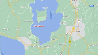
To see an interactive map of San Nicolas, please click on the static image below. You will be redirected to Google Maps using a new browser tab.
This small town, however, has more than its lion’s share of history since this was the site of old Taal, until the latter was forced closer to Balayan Bay by the 1754 cataclysmic eruption of Taal Volcano. When Taal was still in San Nicolas, it was also the provincial capital.
This town can be reached from Manila by road via the Southern Tagalog Arterial Road through Lipa City, Cuenca, Alitagtag, and Santa Teresita. Alternatively, one can pass through Tagaytay through the Payapa road into Lemery and Taal.
To see an interactive map of San Nicolas, please click on the static image below. You will be redirected to Google Maps using a new browser tab.