
PQOG Guerrilla Intel Reports on Batangas Town with Sketch Maps, December 44
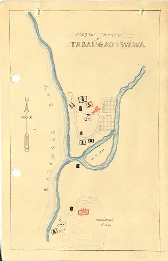
Also included in this page are guerrilla sketches of what presumably were Japanese positions marked in red in the poblacion of Batangas Town, the vicinity of Sorosoro Hill, the Tinga-Labac area and the Tabanga-Wawa area. A legend is included at the bottom of this page.
Generally, sketch maps created by guerrilla outfits operating in Batangas aimed at pointing out to American military planners the positions of the Japanese Imperial Army insofar as these were concerned: troop quarters/positions; gasoline and supply dumps; military headquarters and buildings; artillery and anti-aircraft guns; general defenses like barbed wire enclosures and foxhole concentrations; and airfields and other hubs or locations of military transport.
 |
| American troops move into Batangas Town in 1945. Image credit: US National Archives. |
Transcription of Intelligence Report on Batangas Town
OFFICE OF THE G-2
In the Field
SUMMARY OF INTELLIGENCE REPORTS AS OF
DECEMBER 1, 1944
Batangas, Batangas
b. Many casualties.
b. Many dead and wounded.
b. Building occupied by Jap Navy in barrio Sta. Clara.
c. Tunnel in Tabañgao.
d. Lime bodega 100 meters south of the wireless station.
e. Batangas Elementary School 100 meters from the lime bodega.
f. Red house, 50 meters west of the Roman Catholic Church.
g. Tunnel between Roman Catholic and Chinese Cemeteries west of the wireless station.
h. Alangilan Barrio School, 3 kilometers north of the town along the Manila South Road.
i. Big house, 100 meters NE of the Provincial Capitol.
j. Tinga-Labac and Tinga-Itaas.
k. Caves of the Chinese Cemetery.
l. Hills of Soro-Soro.
2. 600 men at barrio Tinga-Labac.
3. 1,000 men on the hills of Soro-Soro.
4. Provincial Capitol.
5. 100 men at Alangilan School, 3 kms. North of the town along Manila South Road; houses around the school.
6. Manila Mt. northern side facing Taysan.
7. Malalim, Mahabang Dahilig.
8. Nipa houses (small) in Tabangao and Matoco.
9. 3 big houses, south of road crossing in barrio Gulod.
10. Houses in barrio Bihito, Tinga.
2. Tinga-Labac and Tinga-Itaas.
3. 2 tunnels east of the wireless station near the Calumpang River ferry.
2. Mango trees east of the Batangas Elementary School. (small)
3. Tinga-Labac and Tinga Itaas.
2. AA guns near water tower at Sta. Clara.
2. Mountains of Soro-Soro.
3. Old Provincial Jail in barrio Cuta.
2. Old wireless station.
3. Q-boats from Matoco and Tabangao arrive at night and leave early in the morning.
2. Old Sabang-Ibaan Road under construction.
3. Food collection campaign by Japs with promise to pay at their own price giving each town a certain quota. Cases of confiscation without pay.
4. Civilians in Libjo required to raise white flag in their houses.
5. Some soldiers in isolated garrisons raise their own poultry and pigs.
6. Japa military commander for Batangas Prov. Staying in the municipal building of Tanauan, Batangas.
Guerrilla Sketch Maps
Sketch Map of Poblacion Batangas Town
 |
| Image credit: Composite 2nd Regiment, I Corps PQOG. |

 |
| Image credit: Composite 2nd Regiment, I Corps PQOG. |
 |
| Image credit: Composite 2nd Regiment, I Corps PQOG. |
Guerrilla Sketch Map Legend
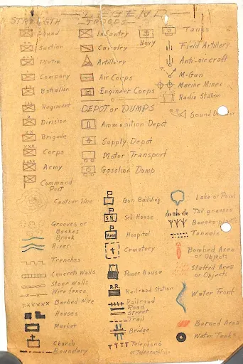 |
| PQOG Guerrilla Map Legend. |
Notes and references:
1 From the files of the Composite 2nd Regiment, I Corps, President Quezon’s Own Guerrillas, online at the United States National Archives.