
The 29 Municipalities of Batangas Province Part II
PART II
PART I | PART II
NASUGBU
The historic town of Nasugbu in western Batangas, famous not just for its beaches and resorts but also for the landing of the United States Eighth Army in January 1945, is the province of Batangas’ largest town in terms of land area. Its territory is made up of 278.51 square kilometers. It is also the most populous town in Batangas, with 136,524 individuals counted during the 2020 Philippine Census. Because of its large land area, however, Nasugbu is sparsely populated with a density of just 490.19 per square kilometers, considered fourth among the province’s least densely-populated towns. Nasugbu is classified as a 1stincome class municipality and it is made up of 42 barrios or barangays.
PADRE GARCIA
The town of Padre Garcia used to be part of Rosario until it separated to become an independent municipality in 1949. It is among Batangas’ smaller towns with a total land area of just 44.51 square kilometers. Considered a 2ndincome class municipality, Padre Garcia’s population was counted at 51,853 after the 2020 Philippine Census. Its population density is relatively high, with 1,249.17 per square kilometer, ranked 9thin the province. Padre Garcia is made up of 18 barrios or barangays.
ROSARIO
Rosario is the third largest municipality of Batangas in terms of land area, with a total of 226.88 square kilometers. It is classified as a first income class municipality and its 2020 population was placed at 128,452 individuals. This figure makes Rosario the second most populous town of Batangas after Nasugbu. However, because of its large land area, the town’s population density is just 565.73 per square kilometer. This makes Rosario the sixth least densely populated town in Batangas. Rosario is a landlocked town made up of 48 barrios or barangays.
SAN JOSE
Known as San Jose Malaquing Tubig during the Spanish colonial era, this town was founded in 1765 after separating from Bauan. It is presently known for its poultry industry. Totally landlocked, San Jose has a land area of 53.29 square kilometers. Its 2020 population was placed at 79,868. Given its relatively small territory — in comparison with the province’s larger towns — it is hardly surprising that the town’s population density ranks sixth in the province with 1,498.74 per square kilometer. San Jose is classified as a 1stincome class municipality and it is made up of 33 barrios or barangays.
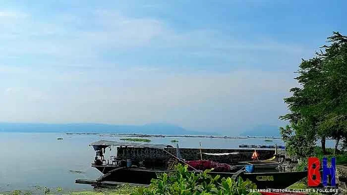 |
| Taal Lake seen from the shore in Talisay. |
SAN JUAN
San Juan, the easternmost town of Batangas is also the province’s gateway to Quezon Province. It is classified as a first income class municipality with a total land area of 273.40 square kilometers. This makes San Juan the second largest in Batangas in terms of land area. As per the 2020 Philippine Census, the population of the town was at 114,068 individuals. San Juan, however, is still largely agrarian, with large swathes of the town’s territory planted with different crops. Despite having Batangas’ third highest population among its towns, San Juan, in fact, is the second least densely populated among Batangas’ municipalities with just 417.22 per square kilometer. The town has a total of 42 barrios or barangays.
SAN LUIS
The Municipality of San Luis used to be part of Taal, until it formally separated in 1861. The town was re-attached to Taal in 1904 under the American colonial regime, but again given independent status in 1918. San Luis has a total land area of 42.56 square kilometers, 19thlargest in Batangas. Its 2020 population was pegged at 36,172, ranked 7thsmallest among Batangas’ towns. Its population density is 849.91, ranked fifteenth among 29 municipalities. A fourth income class municipality, San Luis is made up of 26 barrios or barangays.
SAN NICOLAS
Another lakeside town of Batangas, San Nicolas was the former location of the town of Taal until the latter’s residents were forced towards Balayan Bay by the cataclysmic 1754 eruption of Taal Volcano. The town continued to be attached to Taal as a barrio until it was formally separated in 1955. Its territory is made up of 22.61 square kilometers, third smallest in Batangas. Its 2020 population was counted at 23,908, also third smallest in the province. Because of its small land area, San Nicolas’ population density is relatively high, with 1,057.41 per square kilometer, ranked twelfth in Batangas. The town is a 5thincome class municipality made up of 18 barrios or barangays.
SAN PASCUAL
The Municipality of San Pascual used to be part of Bauan until its formal separation to become independent in 1969. Known for the Caltex Refinery, San Pascual has a total land area of 50.7 square kilometers. The town’s 2020 population was counted at 69,009, giving it a population density of 1,361.12. This figure is ranked seventh highest in Batangas among its towns. San Pascual is made up of 29 barrios or barangays.
SANTA TERESITA
The small Municipality of Santa Teresita began life officially in 1961 with territory taken from the towns of Taal, San Nicolas and San Luis. It is the smallest municipality in Batangas with a land area of just 16.3 square kilometers. Its population of just 21,559 individuals, counted during the 2020 Philippine Census, also ranks second fewest in the province. However, because of the town’s small land area, its population density of 1,322.64 is actually the eighth highest in Batangas among the province’s municipalities. A 5thincome class municipality, Santa Teresita is made up of 17 barrios or barangays.
TAAL
The historic town of Taal, known for its embroidery, the balisong and its heritage houses, has a land area of 29.76 square kilometers. It used to be much larger, until towns like San Nicolas, Lemery and San Luis seceded from it and became independent towns. As per the 2020 Philippine Census, Taal’s population was at 61,460 individuals. The town has the highest population density among Batangas’ municipalities, however, with 2,066.19 per square kilometer. Classified as a 3rdincome class municipality, Taal is made up of 42 barrios or barangays.
TALISAY
The lakeside town of Talisay used to be a part of Taal until it separated in 1869. For a time during the American colonial era, it was also attached to Tanauan. Its total land area is at 28.2 square kilometers, making it Batangas 6thsmallest municipality. The town’s population was placed at 46,238 after the 2020 Philippine Census, ranked 17thamong Batangas’ municipalities. Talisay’s population density ranks fourth among the towns of Batangas, with 1,639.65 per square kilometer. A 3rdincome class municipality, Talisay is made up of 21 barrios or barangays.
TAYSAN
Taysan, a landlocked town to the south of Rosario, is classified as a 2ndincome class Philippine municipality. Formerly known for its mines, Taysan is also of agrarian nature and has a land area of 93.62 square kilometers, ranked 9thamong the municipalities of Batangas. Its 2020 population was placed at 40,146 individuals, ranked 20thamong Batangas’ towns. Taysan is the third least densely populated town of Batangas with just 428.82 among the province’s towns. It is made up of 20 barrios or barangays.
TINGLOY
Tingloy is Batangas’ archipelagic municipality, made up as it is of islands to the south of the Calumpang Peninsula. The town, which at various times during its existence was administered from either San Luis or Bauan, was finally given full autonomy as a municipality in 1955. Its total land area is 33.07 square kilometers, making it the 9thsmallest municipality in Batangas in terms of land area. Its population as per the 2020 Philippine Census was counted at 19,215, the smallest among Batangas’ towns. Its population density is 581.04 per square kilometer, ranked 22ndamong the towns of Batangas. Considered a 5thincome class municipality, Tingloy is made up of 15 barrios or barangays.
TUY
The western Batangas town of Tuy is landlocked and has a total land area of 94.65 square kilometers. Its population as per the 2020 Philippine Census was counted at 45,519 individuals, giving the town a density of just 491.48 per square kilometers. Because of its relative large land area, Tuy’s population density is ranked 5thsmallest among the municipalities of Batangas. Tuy is classified as a 3rdincome class municipality and it is made up of 22 barrios or barangays.
PART I | PART II
Notes and references:
1That, is, a municipality that generates an average annual income of from ₱25M to ₱35M.2A first income class Philippine municipality averages an annual income of at least 55M pesos.
3A fifth income class Philippine municipality averages an annual income of 15M to 25M pesos.
4A second income class Philippine municipality averages an annual income of 45M to 55M pesos.
5A third income class Philippine municipality averages an annual income of from 35M to 45M pesos.