
12 Violent Earthquakes that Rocked Batangas from 1645 to 1901
The shaking of the ground which we all refer to as “earthquake” may be caused by different factors: the collapse of an underground cavern or mine; or perhaps a nuclear of chemical blast. The most common causes of earthquakes, however, are purely natural occurrences: those induced by underground volcanic activity and are, therefore, called volcanic earthquakes; or those caused by movement of tectonic rocks underneath the surface of the earth which are, thus, called tectonic earthquakes1.
In Batangas, earthquakes have been primarily caused by the latter two. Volcanic earthquakes, as one might have already guessed, have down the ages been caused by the province’s small but deadly Taal Volcano. There is, to date, only one known tectonic fault in Batangas, the one relatively recently discovered by Phivolcs in the Calumpang Peninsula. Thus, most of the historically significant tectonic earthquakes in Batangas had been caused by movements of tectonic plates outside of the province, among the most active of which has been the Lubang Fault offshore.
Information about the historical earthquakes contained in this article is culled from a 1910 publication2 compiled by the Jesuit priest Miguel Saderra Maso, at the time of publication also the Assistant Director of the Philippines’ Weather Bureau.
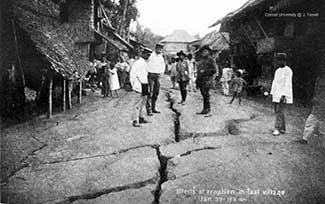 |
| Photo from John Tewell's collection on Flickr. |
The publication listed historical earthquakes from 1599 to 1909. For uniformity, Maso calculated the Intensity of the earlier earthquakes described by Spanish chroniclers using the Rossi-Forel Scale3 which was mostly used in the late nineteenth century.
Maso’s catalogue included only earthquakes Intensity 6 to 10. For this article, however, we shall only be including those of Intensity 8 to 10, which the Rossi-Forel Scale described as
Intensity 8. Damaging Tremor. Fall of chimneys. Cracks in the walls of buildings.
Intensity 9. Devastating Tremor. Partial or total destruction of buildings.
Intensity 10. Extremely High Intensity Tremor. Great disaster, ruins, disturbance of the strata, fissures in the ground, rock falls from mountains.
Intensity 9. Devastating Tremor. Partial or total destruction of buildings.
Intensity 10. Extremely High Intensity Tremor. Great disaster, ruins, disturbance of the strata, fissures in the ground, rock falls from mountains.
While Maso’s date range was from 1599 to 1909, the significant earthquakes that affected Batangas of Intensity 8 to 10 were from 1645 to 1901 only.
1645, Intensity 10
Maso described this earthquake as “the most terrible recorded in the annals of the archipelago.” It destroyed churches, palaces and public buildings from Manila to Cagayan and Ilocos up north and as far south as Mindoro and Marinduque, which means that Batangas was likewise affected. Maso wrote that all writers of the era were united in calling this earthquake the most destructive in Luzon, although understandably the quake’s epicenter was not identified. Wikipedia lists this earthquake at Intensity 84, albeit unannotated.
Maso described this earthquake as “the most terrible recorded in the annals of the archipelago.” It destroyed churches, palaces and public buildings from Manila to Cagayan and Ilocos up north and as far south as Mindoro and Marinduque, which means that Batangas was likewise affected. Maso wrote that all writers of the era were united in calling this earthquake the most destructive in Luzon, although understandably the quake’s epicenter was not identified. Wikipedia lists this earthquake at Intensity 84, albeit unannotated.
1658, Intensity 9
Although Maso placed the 1658 earthquake’s Intensity as one lower than that of 1645, he was quick to note that some historians thought it was just as strong if not as destructive. He also noted that “the epicentral region appears to have included only the southern part of Luzon.” This was, in fact, the last recorded movement of the West Valley Fault Line5. Because of the fault line’s relative proximity to Batangas, presumably it would have caused damage to the province as well.
Although Maso placed the 1658 earthquake’s Intensity as one lower than that of 1645, he was quick to note that some historians thought it was just as strong if not as destructive. He also noted that “the epicentral region appears to have included only the southern part of Luzon.” This was, in fact, the last recorded movement of the West Valley Fault Line5. Because of the fault line’s relative proximity to Batangas, presumably it would have caused damage to the province as well.
1665, Intensity 8
Maso described this June 19 earthquake this way: “Destructive in northern Mindoro and Batangas Province. Mention is made of extensive landslides, the opening of many fissures and the subsidence of large tracts on the beach of the northeast coast of Mindoro. The repetitions were many and severe.” Wikipedia lists this earthquake as magnitude 5.5 with Manila as location. The listing is unannotated.
Maso described this June 19 earthquake this way: “Destructive in northern Mindoro and Batangas Province. Mention is made of extensive landslides, the opening of many fissures and the subsidence of large tracts on the beach of the northeast coast of Mindoro. The repetitions were many and severe.” Wikipedia lists this earthquake as magnitude 5.5 with Manila as location. The listing is unannotated.
1749, Intensity 9
A volcanic earthquake accompanying the violent eruption of Taal Volcano in August of this year. Maso wrote: “The convulsions of the ground were very remarkable; displacement occurred and fissures, both wide and deep, opened in the entire Province of Batangas and likewise in Cavite Province, up to Lake Bay.” There were so many tremors, according to Maso, that inhabitants of Intramuros in fear and lived in tents or structures made of bamboo and nipa.
A volcanic earthquake accompanying the violent eruption of Taal Volcano in August of this year. Maso wrote: “The convulsions of the ground were very remarkable; displacement occurred and fissures, both wide and deep, opened in the entire Province of Batangas and likewise in Cavite Province, up to Lake Bay.” There were so many tremors, according to Maso, that inhabitants of Intramuros in fear and lived in tents or structures made of bamboo and nipa.
1754, Intensity 10
In what had been a remarkable century for Taal Volcano came this third major eruption, which generated an Intensity 10 tremor in May according to Maso. The eruption lasted all the way till December of this same year. All the towns around Lake Bombon (Taal Lake) were destroyed and had to be rebuilt farther away from the volcano. He wrote: “The spasms, separated by intervals of greater or less duration, lasted 7 months, the principal outbursts being always accompanied by very intense earthquakes which made themselves felt throughout a large part of Luzon, on Mindoro Island, and northern Panay.”
In what had been a remarkable century for Taal Volcano came this third major eruption, which generated an Intensity 10 tremor in May according to Maso. The eruption lasted all the way till December of this same year. All the towns around Lake Bombon (Taal Lake) were destroyed and had to be rebuilt farther away from the volcano. He wrote: “The spasms, separated by intervals of greater or less duration, lasted 7 months, the principal outbursts being always accompanied by very intense earthquakes which made themselves felt throughout a large part of Luzon, on Mindoro Island, and northern Panay.”
September 1852, Intensity 9
This September earthquake was felt not just in Batangas but also in Manila, Rizal, Laguna, Cavite, Tayabas, Bataan, Zambales, Pampanga, Bulacan, and Nueva Ecija. In Batangas, fissures opened up in the land and there were landslides. There were also subsidences or depressions in the landscape that were created by the frequent motions of the earth. Aftershocks continued until the middle of the following month.
This September earthquake was felt not just in Batangas but also in Manila, Rizal, Laguna, Cavite, Tayabas, Bataan, Zambales, Pampanga, Bulacan, and Nueva Ecija. In Batangas, fissures opened up in the land and there were landslides. There were also subsidences or depressions in the landscape that were created by the frequent motions of the earth. Aftershocks continued until the middle of the following month.
December 1852, Intensity 9
The second violent earthquake to affect Batangas in three months, and this time the epicenter must have been closer to Batangas. Maso wrote: “Destructive earthquake in Batangas Province and northern Mindoro. Ruined many buildings, among which were the church of Taal and the church and convento of Bauang; the church of Batangas likewise suffered severely.”
The second violent earthquake to affect Batangas in three months, and this time the epicenter must have been closer to Batangas. Maso wrote: “Destructive earthquake in Batangas Province and northern Mindoro. Ruined many buildings, among which were the church of Taal and the church and convento of Bauang; the church of Batangas likewise suffered severely.”
1863, Intensity 10
Maso said that this earthquake was comparable to the one in 1645. Manila was severely affected as were towns in Rizal, Laguna and Cavite. While Maso did not say so, a tremor of this magnitude would have been felt in Batangas, with some damages as well.
Maso said that this earthquake was comparable to the one in 1645. Manila was severely affected as were towns in Rizal, Laguna and Cavite. While Maso did not say so, a tremor of this magnitude would have been felt in Batangas, with some damages as well.
1869, Intensity 8
This October earthquake affected Rizal, Laguna, Cavite and Batangas. There was also considerable damage to some buildings in Manila. In Batangas, a few churches and convents were wrecked, albeit thankfully there was no loss of life. Aftershocks went on for five days after the main tremor.
This October earthquake affected Rizal, Laguna, Cavite and Batangas. There was also considerable damage to some buildings in Manila. In Batangas, a few churches and convents were wrecked, albeit thankfully there was no loss of life. Aftershocks went on for five days after the main tremor.
1872, Intensity 8
This December earthquake affected the “region southwest of Manila.” Maso wrote: “It did considerable damage to buildings in the Provinces of Bataan, Cavite, and Batangas. The towns which suffered most severely were Balanga, Tuy, Nasugbu, Calaca, Balayan, Taal, and Batangas. Several shocks of small Intensity preceded the principal quake between 6 and 9 o'clock.”
This December earthquake affected the “region southwest of Manila.” Maso wrote: “It did considerable damage to buildings in the Provinces of Bataan, Cavite, and Batangas. The towns which suffered most severely were Balanga, Tuy, Nasugbu, Calaca, Balayan, Taal, and Batangas. Several shocks of small Intensity preceded the principal quake between 6 and 9 o'clock.”
1889, Intensity 8
This May earthquake was severely felt in Batangas and northern Mindoro. Wrote Maso: “It wrecked the church at Ibaan and severely damaged the church and other buildings in Batangas, Bauang, Calapan, and several other towns.”
This May earthquake was severely felt in Batangas and northern Mindoro. Wrote Maso: “It wrecked the church at Ibaan and severely damaged the church and other buildings in Batangas, Bauang, Calapan, and several other towns.”
1901, Intensity 8
Another Intensity 8 earthquake hit Batangas late this year, although damage was limited. Maso wrote: “Very violent earthquake in southern Luzon. Some towns in Batangas Province suffered slight damage.”
Another Intensity 8 earthquake hit Batangas late this year, although damage was limited. Maso wrote: “Very violent earthquake in southern Luzon. Some towns in Batangas Province suffered slight damage.”
Notes and references:
1 “Types of Earthquakes,” online at The Southern California Integrated GPS Network Education Module.2 “Catalogue of Violent and Destructive Earthquakes in the Philippines, with an Appendix Earthquakes in the Marianas Islands 1599-1909,” by the Rev. Miguel Saderro Maso, S.J., published 1910 in Manila.
3 “Rossi-Forel Scale,” Wikipedia.
4 “List of earthquakes in the Philippines,” Wikipedia.
5 “What dangers await when the West Valley Fault moves?” online at Rappler.