
The Macolod Volcanic Corridor and Volcanism in Batangas Province
Taal Volcano, the last major eruption of which was in January 2020, is but part of a chain of still active Quarternary — in geologic terms, some 2.5 million years ago to the present1— volcanism called the Macolod Corridor2. This corridor is some 40 kilometers wide, the northern edge of which runs from Tagaytay Ridge to the Jalajala Peninsula that juts into Laguna de Bay from Rizal Province; while its southern edge runs from Batangas Bay to Mt. Banahaw in the Province of Laguna.
This corridor is, in turn, part of a chain of volcanoes approximately 1,200 kilometers in length that arcs all the way from Taiwan in the north to the south of the island of Mindoro in the Philippines. It is made up of two volcanotectonic decompressions or calderas, a scattering of stratovolcanoes and more than 200 scoria cones and maars.
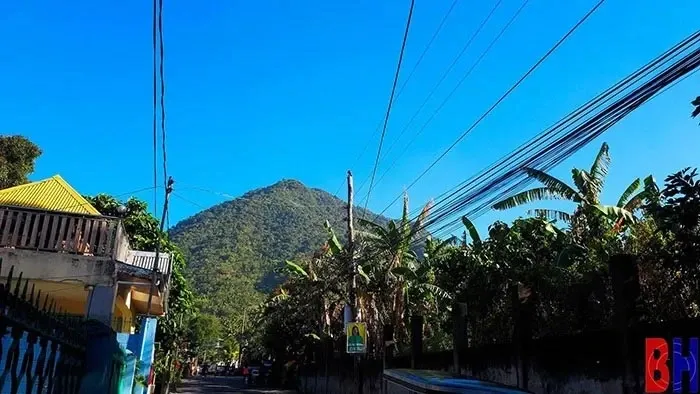 |
| Mt. Maculot as seen from Barrio Labac, Cuenca, Batangas. |
A caldera is a large cauldron-like hollow on the ground’s surface that was formed after the collapse through a major eruption of a chamber where the magma – hot fluid or semi-fluid from which lava forms after it cools – had pushed up from deep inside the earth. The two calderas along the Macolod Corridor are Taal Lake and Laguna de Bay.
A stratovolcano, meanwhile, is a large mound of earth made up of accumulated layers of viscous lava and tephra – fragments and particles of rock. Because the lava is more viscous than in other volcanoes and effectively acts as “plugs” which allow gas pressure to build up, the eruptions of stratovolcanoes tend to be very explosive3.
In the Macolod Corridor, the more prominently known stratovolcanoes are Mts. Banahaw and Makiling in the Province of Laguna; and the Mt. Malepunyo range just east of Lipa City in Batangas.
However, in Batangas alone, there are several other stratovolcanoes considered either inactive or potentially active by the Philippine Institute of Volcanology and Seismology (PHIVOLCS): Mt. Panay on the southern edge of the Calumpang Peninsula; Mt. Pinamucan near the southeastern end of Batangas Bay; Mts. Pico de Loro, Batulao and Cariliao near the Nasugbu-Cavite boundary; and, of course, Mt. Macolod – or Maculot as it is known locally – in Cuenca, Batangas, after which the entire corridor has been named.
A maar is a broad and shallow coneless crater filled in over time with water to become a lake. The Sampaloc Lake in San Pablo City is a good example of this type of volcano. Scoria or cinder cones, on the other hand, are mounds of earth or hills generally less than 300 meters in height4. Most maars and scoria cones are considered monogenetic. In other words, they erupt only once and after doing so become extinct.
As mentioned, there are more than 200 scoria cones along the Macolod Corridor. Examples of these in the Province of Batangas are Anilao Hill in Lipa City; Bigain Hill in San Jose; Soro-soro Hill in Batangas City; and Tombol Hill in Rosario. All are considered to be extinct volcanoes.
No discussion on volcanism in Batangas will ever be complete without touching on the famous Taal Volcano, known for its scenic beauty when it rests and also for its destructiveness when it is agitated. The volcano is anything but simple. Its caldera has been filled in with water over time and is commonly known as Taal Lake.
All of the volcano’s eruptions in its recorded history — totaling almost 40, making it the second most active in the Philippines — have come from vents or eruptive centers within a 5 kilometer5circumference from what is called the Main Crater Island inside Taal Lake.
These eruptive centers or “potential eruption vents” had previously been identified by PHIVOLCS as shown in the image below: the Main Crater Island, Binintiang Malaki (also known as the “Fake Volcano” as it is frequently the postcard face of the volcano), Binintiang Munti, Pirapiraso and Off-Calauit Point.
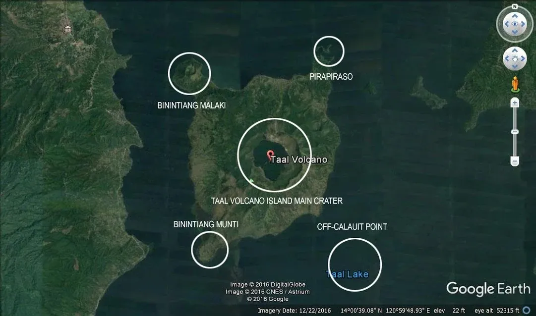 |
| The identified vents of Taal Volcano. Image credit: Google Earth. |
2 Along with other details contained in this article, from “The Macolod Corridor: A Rift Crossing the Philippine Island Arc,” by Ulrich Knittel, Marc J. Defant, Hansgeorg Förster, Dietmar Oles and Ronnie C. Torres, published November 1990 in Tectonophysics.
3 “Stratovolcanoes,” author and publication date unknown, online at “Volcano World,” hosted by the Oregon State University.
4“How Volcanoes Work: Scoria Cones,” author and date of publication unknown, online at the San Diego State University College of Sciences.
5“Taal Volcano,” author and date published unknown, online at Volcano Discovery.