
Bauan, Batangas in the 19th Century as Described by a Spanish Historian
We continue with the series of articles on 19th Century Batangas as described by the former Spanish government official and historian Manuel Sastron in his 1895 book “Batangas y su Provincia1.” Presumably, the information contained in the book was gathered in the immediate years prior to the book’s publication.
This time, we turn our attention to the town of Bauan, founded originally along the shores of Taal Lake but presently located at the Calumpang Peninsula by the shores of Batangas Bay. Sastron began his description of the town by saying that it was 7 kilometers from the capital town of Batangas. This distance is just about right as the crow flies.
He went on to say that Bauan was bounded to the north by Lake Bombon (Taal Lake in the present day); by the towns of Cuenca and San Jose to the east; by the towns of San Luis and Taal to the west; and Batangas Bay to the south. At this time, the town of Alitagtag was still part of Bauan. In the present day, of course, with Alitagtag having become a separate municipality, Bauan no longer has access to Taal Lake.
The town at this time had 36,272 inhabitants. In comparison, as per the 2015 Philippine Census, this number had grown to 91,297.
Sastron estimated Bauan’s irrigated lands to have the capability to produce 45,000 cavans – a cavan being roughly 75 liters2 – presumably of rice. It was a peculiarity of Sastron’s writing style that he sometimes described the amount of land a town had by hectares and sometimes by its capacity to produce in terms of cavans.
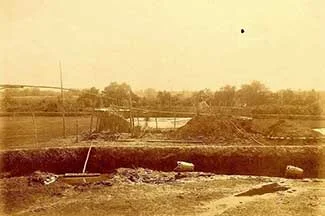 |
| A salt field in Bauan early in the American era. Image credit: University of Michigan Digital Collections. |
Bauan also had unirrigated lands – “rain-fed” was the term he used – that produced about 1,600 cavans. The town’s crops were more or less the same as those raised by the town of Batangas, but with probably more coffee and oranges3 than the capital.
There were no major rivers that flowed through the town, but there were a few streams and estuaries which ran through the villages of Camutain, Real, Bañadero, Muntingtubig and Sinala. There were also streams in Malimasoc, Suluc, Balete de San Andres and Mainaga.
Bauan could be reached by a main road from the town of Batangas. This same road went on all the way to Taal. This road was “fairly wide” and “well-maintained” and could be used by all types of carriages. There were both wooden and iron bridges along this road. Those in the villages of Lagnas and Manghinao needed to be repaired.
There were also roads that branched from the main one leading to San Luis and Cuenca; and from the latter, San Jose could be reached but by “narrow paths.”
Bauan’s church and convent, Sastron noted, were “splendidly” constructed with tasteful architecture and solid materials. The convent was destroyed by the 1852 earthquake, which according to Fr. Miguel Maso’s catalogue4 of violent tremors was an intensity 9 shaker5. It was reconstructed when one Fr. Huerta was the parish priest.
Sastron paid a glowing tribute to Bauan’s former parish priest, who must have recently died after dedicating his life to the “exercise of his sacred ministry.” His name was Fr. Felipe Bravo, of the Augustinian order. This priest was committed to the “cultivation of letters and sciences” and was at the same time “a lover of the fine arts.”
Bravo co-authored a geographic, statistical and historical dictionary of the Philippines, which was published in Madrid in 1850. He was always communicating with his parishioners, many of whom he helped personally. He encouraged these same people not only to live Christian lives but also to love the country and its institutions.
[Sastron had more to say about Bravo, but mostly irrelevant to this narrative on Bauan and, therefore, excluded.]
Bauan had two primary schools, both of which were well attended. “Crowded,” in fact, was the word Sastron used to describe these. One, presumably the school for boys, was located in one part of the court house. The other was in a private house.
Sastron wrote that Bauan’s industries were similar to those of the town of Batangas. It had a robust weaving industry, however. Most houses possessed one or two looms so that the town had become known for its production of fabrics. Buyers from other towns often went to Bauan to buy these at the market. These fabrics were also exported by Bauan to Manila and other southern provinces.
Although close to Balayan Bay, Bauan’s fishing industry was comparatively small, with just a few fish pens in Dagatan and Calvo. The town had 2,500-3,000 heads of cattle, some 200 carabaos and 400-500 horses.
Although Sastron wrote that Bauan was “a fairly healthy town,” there were also many cases of malaria in some of its villages.
2 “Cavan,” Wikipedia.
3 The orange or “naranja” that Sastron referred to was of the Mandarin variety that was grown in the tropics. The type grown in Batangas at the time was either the “dalandan” or “sinturis.”
4 “Catalogue of Violent and Destructive Earthquakes in the Philippines, with an Appendix Earthquakes in the Marianas Islands 1599-1909,” by the Rev. Miguel Saderro Maso, S.J., published 1910 in Manila.
5 As per the Rossi-Forel Scale