
Taal Lake's Forgotten Past: How a Volcanic Eruption Reshaped It
Even to those Batangas born and raised, knowledge of Taal Lake is often limited to that which was taught in elementary geography: that it is a freshwater lake; that inside it is a small but active and dangerous volcano that bears the same name; that it is home to fish species found nowhere else in the world; and that, seen from the Tagaytay ridge, it is always postcard perfect.
There are, however, many things about Taal Lake that the geography books fail to say about its storied past. In the present day, this body of water is land locked, albeit with outlets to Balayan Bay. This has not always been the case.
In the 1595 map called India Orientalis1 by the Flemish cartographer Gerardus Mercator2, what is known as Taal Lake in the present but Bombon at the time was shown as an inlet of Balayan Bay. Obviously, given the state of technology at the time, or lack thereof, the map is far from accurate.
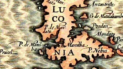 |
| Excerpt from India Orientalis by Gerardus Mercator. |
 |
| The Jacques Nicolas Bellin Map. |
The Agustinian priest Fr. Juan de Medina wrote in 1603 that the waters of Taal Lake were salty. This was contested by the Historian Percy A. Hill in an article published in 1937. Hill’s opinion, however, was that the waters were at least brackish or a combination of freshwater and seawater.5
However, the Spanish chronicler Joaquin Martinez de Zuñiga wrote in 1593 that there were different species of tuna that were caught in Taal Lake; but he also observed that these were not as good as the ones caught in Spain.6
This seems to add credence to Medina’s record of the lake’s waters being salty because tuna is strictly a marine or saltwater fish belonging to a subgroup of the mackerel family.7 If the antique maps had any reliability to them at all, then it is really not hard to imagine seawater getting that far inland through the channel.
In the lake, even to the present day, can be found one of only two species of sea snakes which make their habitat in freshwater: hydrophis semperi or the extremely rare Philippine freshwater sea snake. This snake can only be found in Taal Lake.
All other snakes belonging to the hydrophide family are marine. Thus, the Philippine freshwater sea snake is believed to have originally lived in salty waters but has been forced to adapt to the environment as Taal Lake gradually lost its salinity after it was locked inland.8
But obviously, at this point the relevant question to ask always will be how Taal got locked in to begin with.
It is believed that the Pansipit River is what remains of the channel to the sea documented by Murillo Velarde and Bellin in their respective maps. Then, the channel was a navigable passageway through which ships and Chinese junks regularly passed on their way to and from Balayan Bay to the towns surrounding the lake.9
 |
| The Pansipit River. Image property of Batangas History, Culture and Folklore. |
Taal Volcano’s eruption of 1754, the most violent in recorded history, is believed to have been responsible for the reduction of the Pansipit River and for locking in Taal Lake. The eruption started on the 15th of May and went on until the 1st of December.
A Fr. Buencuchillo, parish priest of Sala, a town in what is present-day Tanauan, gave a chilling account of the first day of the volcano’s eruption:
“On May 15, 1754, at about 9 or 10 o'clock in the night, the volcano quite unexpectedly commenced to roar and emit, sky-high, burning flames intermixed with glowing rocks which, falling back upon the island and rolling down the slopes of the mountain, created the impression of a large river of fire.10”
Historian and writer Pedro M. Picornell theorised that the channel was blocked in December of 1754. There were reported floods in the towns of Taal and Lipa the previous month, likely caused by powerful typhoons which, we all know, tend to occur towards the end of the year.
Picornell’s theory, therefore, was that the channel was blocked by the deadly combination of floodwaters and volcanic debris.6 We all need look back no farther than 1991 to see exactly how deadly the combination can be. The fatal combination of Mt. Pinatubo’s eruption with the passing of Typhoon Diding – international code name Yunya – was beamed into our television sets by the evening news.
Of course, the coming of the New Year in 1755 also brought with it the start of the dry season, which allowed the volcanic debris time to harden and set. With the onset of the monsoon season the following June, the blocked channel began to accumulate water, which would subsequently inundate several towns that were built close to the shores of the lake.
Whereas before 1754, Taal Lake’s surface was level with the sea as obviously it was an extension of Balayan Bay, after the major eruption that year, the surface rose steadily to the five metres above sea level it is at the present day. The annual monsoons also gradually reduced the lake’s salinity until it became completely freshwater as it is today.11
Since 1754, therefore, Taal Lake has been no different from a vat that is being filled with water. This explains why Taal Lake in the present day is larger than it was before the channel was blocked, as seen from the antique maps.
According to Hargrove and Medina, lake fishermen referred them to the “sapao” while they searched for sunken ruins in Taal Lake. In their paper, they erroneously defined “sapao” as a Tagalog word which means “built up structures under the water.6”
I am not sure if “sapaw” is Batangas dialect; but what I am sure of is that it means “to be inundated.” That is why, figuratively, the word is also contemporarily used to mean “overshadowed.”
At any rate, it has long been known by local lakeside dwellers, probably knowledge handed down from one generation to another, that there are ruins lying under the surface of Taal Lake of towns abandoned by inhabitants as the water levels rose after the blocking of the channel to Balayan Bay.
As a final note to this article, it may surprise many readers – as it did me – that bull sharks actually swam in Taal Lake and through the Pansipit River as recently as the 1930s. The bull shark is known to thrive in marine, brackish or even freshwaters and would still be swimming in the lake till the present day; but unfortunately was hunted to extinction.11
2 Gerardus Mercator, online at Encyclopædia Brittanica
3 A Hydrographical and Chorographical Chart of the Philippine Islands, online at World Digital Library
4 Carte Reduite des Isles Philippines, online at Barry Lawrence Ruderman Antique Maps, Inc.
5 Percy A. Hill, Taal and Its History, published in the Philippine Magazine, 1937.
6 Sunken Ruins in Lake Taal: An Investigation of a Legend, by Thomas R. Hargrove and Isagani Medina, published 1988 in the Philippine Studies journal of ADMU
7 Tuna, Wikipedia
8 Hydrophis semperi, Wikipedia
9 Pansipit River, Wikipedia
10 Taal Volcano, Wikipedia
11 Taal Lake, Wikipedia