
Revisiting the Forgotten WWII Airstrip in Malvar, Batangas
In his 1951 book1 on the US Army Air Force’s exploits at the outbreak of World War II in the western Pacific, author Walter D. Edmonds noted that there were airstrips hastily constructed by US Army engineers in the towns of Tanauan and Lipa in Batangas after the 8th of December 1941.
Building Airstrips in Batangas
What became of the airstrip in Lipa is more or less common knowledge to people in Batangas – it was expanded by the Japanese Army and used during their occupation of the country; taken over by the US Army during the liberation of Batangas; and turned over to the Philippine Air Force after the war to become Basilio Fernando Air Base.
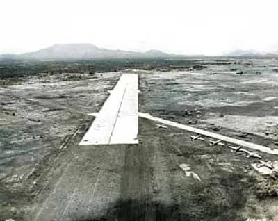 |
| The Lipa Airstrip. Image credit: US National Archives. |
RELATED ARTICLE: “Fernando Air Base: Its World War II Roots”
There were, according to Edmonds, in fact three airstrips built in Tanauan in December 1941. What became of these is a tad more difficult to establish. In fact, one of these was probably not even in Tanauan but, instead, in the neighboring municipality of Malvar.
The creation of these airstrips was something of a kneejerk reaction to the attack on Pearl Harbor, undertaken more in hope rather than certainty that B-17 bombers would be sent over from the mainland United States. They were built, Edmonds wrote, in the absence of graders and bulldozers “using primitive means, stone boats, and carabao carts” and stones were carried in “baskets by men and women.”
Regrettably, the hoped-for bombers never arrived; and when the order to retreat to the Bataan Peninsula was sounded, as Edmonds noted, “the newly completed airfields at Tanauan and Lipa were automatically at the disposal of the Japanese.”
The Malvar Airstrip According to Guerrillas
That the Japanese used the airstrip in Lipa is well-documented. On the other hand, most of the materials available on a Tanauan airstrip invariably refer to the one in Leyte rather than Batangas. In fact, while generally still scanty, documentation points at an airfield used by the Japanese Army in Malvar rather than Tanauan.
In the casualty roster of the Malvar Guerrilla Forces, an affiliate of the President Quezon’s Own Guerrillas (PQOG), it was noted that one Cpl. Modesto Unigo was killed, presumably by the Japanese, at the Malvar Landing Field2 while doing espionage work3.
In the historical account of the Lipa Guerrilla Regiment (Paran’s Unit), it was mentioned that in April 1944, one Major Saludo made “a complete draft of the Malvar Airfield” and that a copy of this sketch was forwarded to Col. Felino Paran, commanding officer of the unit4.
There were several other mentions of the Malvar airstrip in this same document, the most notable of which was an account of a second American air raid on the airstrip in October of 1944, one which had both Filipino and Japanese laborers scampering “for safety in confusion5.” Guerrillas took advantage of the confusion to set on fire the gasoline dump and explosives storage at the airstrip.
Finally, the Santo Tomas unit of the PQOG, documented that one Capt. Nicasio Torres, with two men of the unit, visited Major Jay D. Vanderpool of the US Army early in 1945 with “reports on enemy installations and strength at Sta. Clara, Santo Tomas, Tanauan, Malvar Landing, and Daraza (Tanauan) School6.”
The Malvar Airstrip in Publications
That the Malvar airstrip existed and was targeted by American warplanes because it was in Japanese hands were corroborated by other publications. In his 1984 book about sorties by US Navy carrier-based planes in the western Pacific in World War II, author Edwin Palmer wrote:
Meanwhile, a short news item in a March 1945 edition of the newspaper Manila Free Philippines, stated that as the 11th Airborne Division of the US Army moved “northward within a mile of the key rail and road center of Lipa,” the 1st Cavalry had moved south from Tanauan to seize Malvar airfield8.
Finally, in the published report of General Douglas MacArthur on operations in the Southwest Pacific Theater of War, while no particulars were given on the Malvar airstrip or military activities undertaken against it, it was nonetheless included in a map showing operational Japanese airfields in Luzon by 31 December 19449.
 |
| The reports of Gen. MacArthur on WWII included the Malvar Airstrip among operational fields used by the Japanese. |
At this point, it has already been established that one of three airstrips supposedly built by the Americans in Tanauan and subsequently used by the Japanese was, in fact, in the neighboring municipality of Malvar. Any mistakes in documentation can be easily attributed to American servicemen being unfamiliar with the province of Batangas.
But where was the airstrip located in the first place? To answer this question, the writer turned to social media and posed a simple question to connections who live or might have lived in the town of Malvar: “Has anyone heard of a place called ‘Landing’ in your town?”
In towns around Batangas where there were once airstrips, locals uniformly referred to these as “Landing” — short for “landing field,” an alternative term to airstrip or airfield.
As often happens in social media, a viable answer did not take long to arrive. Anna Latayan Lado-ing, a resident of Malvar, replied that her grandparents, Cesario and Eleuteria Latayan, used to own a piece of land that used to be part of the Japanese landing field in the town.
The property used to be in the area of what is now the Kassel Pacific Subdivision in the barrio of San Pedro I. The barrio is slightly to the northwest of the town center of Malvar and a stone’s throw from the barrio of Banjo East, which as locals know is already in the municipality of Tanauan.
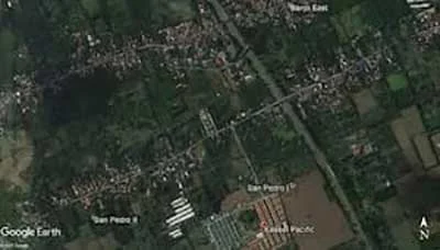 |
| The barrio of San Pedro I where the Malvar Airstrip probably was next door to Tanauan. |
2 Alternatively, the Malvar airstrip was referred to as the Malvar landing strip or just Malvar landing.
3 “Malvar Grla Forces, I Corps, PQOG,” File No. 271-27, downloaded from PVAO.
4 “Lipa Guerrilla Regiment Paran’s Unit,” File No. 23, online at PVAO.
5 Ibid.
6 “Sto Tomas Grla Unit, I Corps, PQOG,” File No. 271-29, online at the United States National Archives.
7 “McCampbell's Heroes: the Story of the U.S. Navy's Celebrated Carrier Fighters of the Pacific War,” by Edwin Campbell, published 1984 in New York.
8 “More Cebu Towns Freed by New Gain,” Manila Free Philippines, Volume II No. 7, 29 March 1945
9 “Reports of General MacArthur: The Campaigns of MacArthur in the Pacific, Volume I,” by General MacArthur's Staff, first published 1950 in the United States.