
A 1914 Batangas Road System Map
The turn of the 20th century in Batangas saw the new American colonial government, through the Bureau of Public Works, execute an ambitious infrastructure project that was aimed at improving the standard of living in the Philippines as well as stimulating the economy. The Americans started constructing roads, a rail network, government and other public buildings, water systems and many others.
In Batangas, as early as the year 1900, the Americans started constructing the Batangas-Calamba Road. Initially, the intention of the road-building program was to facilitate the movements of the invading United States Army during the Philippine-American War. The war having ended in 1902, the new colonial government started planning and executing road construction elsewhere in Batangas.
In a 1914 report1 by the Bureau of Public Works, the Americans acknowledged that the previous Spanish regime had laid out “a wonderfully complete” road system. The problem was, however, that the road network that the Spaniards had planned and laid out was far from complete.
It was left to the Americans to not only complete the road system but to do so with modern technology. The Bureau of Public Works even brought into Batangas a stone crushing machine to cut down on the time and the accompanying costs of shipping in the crushed stone or macadam to be used in road construction.
Below is a copy of the public works road system map in 1914, digitally extracted from the July 1914 edition of the Bureau of Public Works Quarterly Bulletin. The map shows existing first class roads, second class roads and third class roads, along with first class roads under construction at the time.
Because the Batangas to Cavite road through the Tagaytay range was, at the time, still non-existent, the kilometer marking was done from Manila through the towns of Santo Tomas, Tanauan, Lipa, Batangas, Bauan, Taal, Lemery, Calaca, Balayan, Tuy and then Nasugbu.
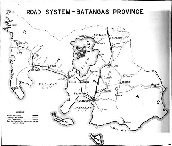 |
| A Batangas Road System Map. Image digitally extracted from the July 1914 edition of the Bureau of Public Works Quarterly Bulletin. |